Backcountry Skiing History Rock
A popular spot for meadow skiing that is close to Bozeman and has easy access.
Overview
History Rock is likely the most popular backcountry skiing access point in Hyalite. Named after a boulder next to the summer hiking trail where yokels etch their name, its close location to Bozeman, relatively safe terrain and short ascent mean that this is a confidence inspiring location and great place to get a quick backcountry workout. Given its popularity you aren’t likely find untouched powder here unless you hit it on a snow day, or you head up to the highest of the three short skiable meadows at History Rock where the terrain opens up and sees less traffic.
Avalanche Information
Avalanches are unlikely at History Rock due to its low angle terrain and relatively high skier volume which tends to regularly consolidate and break up weak layers in the snow that start to form. Like any skiable terrain the backcountry, a slide at History Rock could still occur under the right conditions so don’t forget your good avalanche awareness skills.
Getting There
Take 19th Avenue south out of town and follow it as it bends around to the right and continues heading west. Look for the sign to Hyalite Canyon and take a left. Follow the canyon road until you notice a plowed parking area to the right that says History Rock at the trailhead. If you reach the reservoir, you've gone too far.
Descent Close-Up

There are three short skiable meadows at History Rock, each at a slightly higher elevation than the previous one, and so each has progressively better snow conditions and sees less traffic. The highest of the three meadows is a more easterly aspect that shelters the snow from the sun better than the first two, and almost always has the best skiing. After a lap or two on this short but sweet third pitch, you can then head back down and ski the other two pitches on your way out. The trip back to the car is generally pretty fast and snowboarder friendly except for the very last bit where you pass through a flat meadow that will require some cross country to reach the parking lot.
Map of the Area
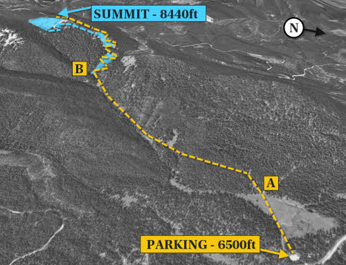
From the parking lot, follow the well traveled cross-country ski trail across the meadow and make sure you catch the skin track as it begins to ascend up the hill (A) and leaves the flat field. The approach follows the History Rock hiking trail for most of the approach, but breaks off from the trail and continues following the drainage uphill. Once at the base of the first small meadow (B), the trail switchbacks and gains elevation on the skinner's right of the first meadow.
This route and 28 others are available in the book, along with GPS waypoint coordinates, full color photographs, and detailed statistics on each adventure.